
The high, rolling hills between Moffat and Peebles in southern Scotland encompass White Coombe, one of the area's seven Corbetts. This route offers a chance to gain the high ground with relative ease, then stride out for hours on end over long, broad ridgelines.
There’s a sense of space and openness here that you won’t get in more densely-packed mountain groups, with fair-weather views rarely stretching less than 70km in each direction. There’s also a sense of remoteness and, although paths are testament to the fact that walkers do come this way, you’ll probably only encounter these rare beasties on sunny weekends.
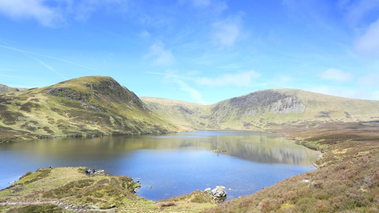
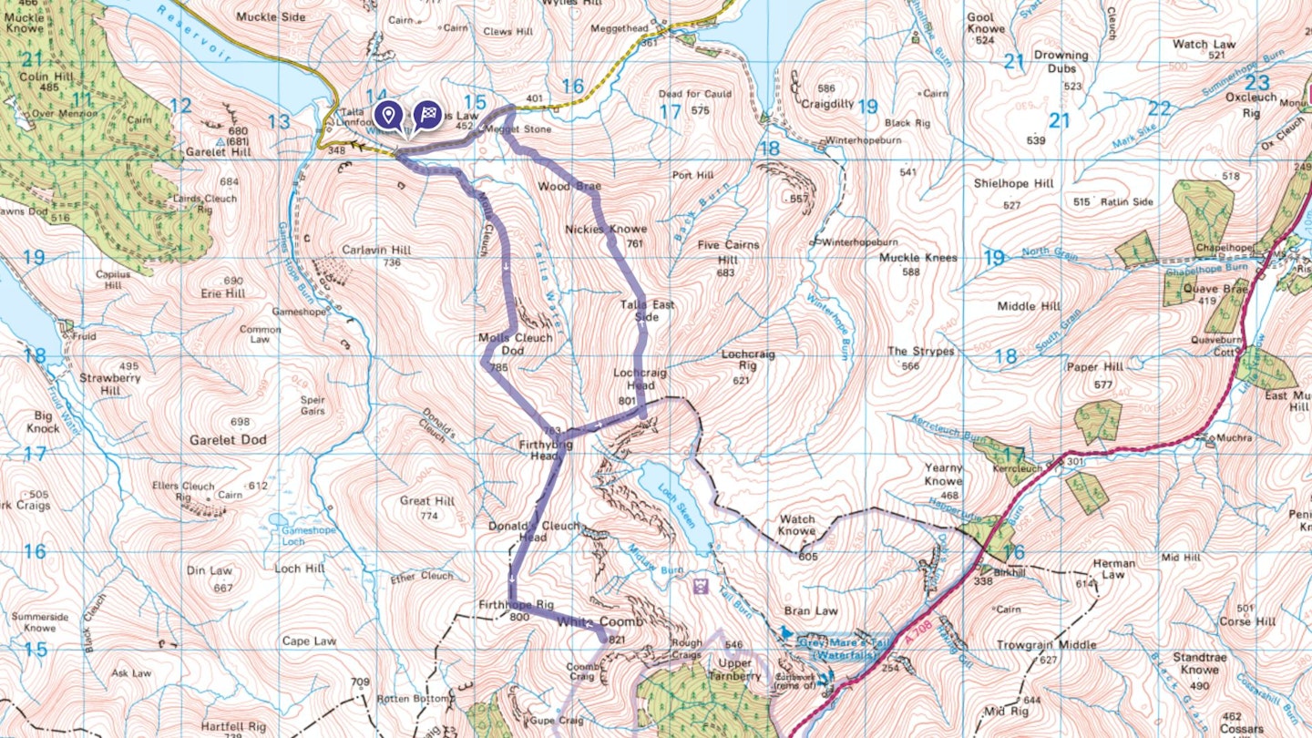
With A-roads and a single-track road behind you, the walk starts from a high point between the Talla and Megget reservoirs. It heads into the Borders Forest Trust’s Talla & Gameshope site, an area that, like the charity’s neighbouring Carrifran Wildwood, is being returned to a more natural state.
From Firthybrig Head, a 5.5km there-and-back spur (included within the total distance given) climbs the 821m White Coomb. Returning to Firthybrig Head, views of the dramatically located Loch Skeen come and go before another easy-going ridge is followed back towards the valley.
How hard is climbing White Coomb?
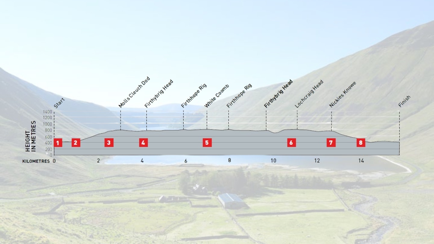
DIFFICULTY: Medium | DISTANCE: 15.8km | TIME: 5 1/2 hours | TOTAL ASCENT: 690m
FITNESS: Moderate fitness is needed for the ascents, but there are long sections of mostly level walking.
TERRAIN: Grassy, rounded hills with long, easy-going ridges; small areas of boggy ground; one normally straightforward ford near the start.
NAVIGATION: Easy on the high ground thanks to fences and other handrails; 800m section, point 8, is on indistinct, sometimes boggy path.
Where is the start of the walk?
Start from large layby on single-track road between Tweedsmuir and St Mary’s Loch, 800m west of the Megget Stone, but no public transport.
What's the best map for Talla Water & White Coomb?
-
CLICK HERE to view and download our digital route guide in OS Maps
Talla Water & White Coomb | Step-by-step route guide

-
From the layby, walk west along the road, cross the bridge over Talla Water and take the track on the left. This heads up the valley to a large shed and then continues steadily uphill, switching to grass on nearing Molls Cleuch.
-
Ford the burn. A broad, mostly grassy path climbs briefly east before swinging south-east to reach the ridge. Continue uphill, following the wooden posts of the now deceased ridge fence. The climb briefly eases before another pull to the top of Talla Craigs. Here, the path passes between two posts.
-
Bear right, following another line of posts south-west for about 150m and then bear left at a faint fork to head south-south-west. The trail passes a tiny cairn marking the true summit of Molls Cleuch Dod and continues to a larger cairn on the far side of a tumbledown wall. Turn left, following the line of the wall south-east. It dips and climbs to a stile and locked gate on Firthybrig Head.
-
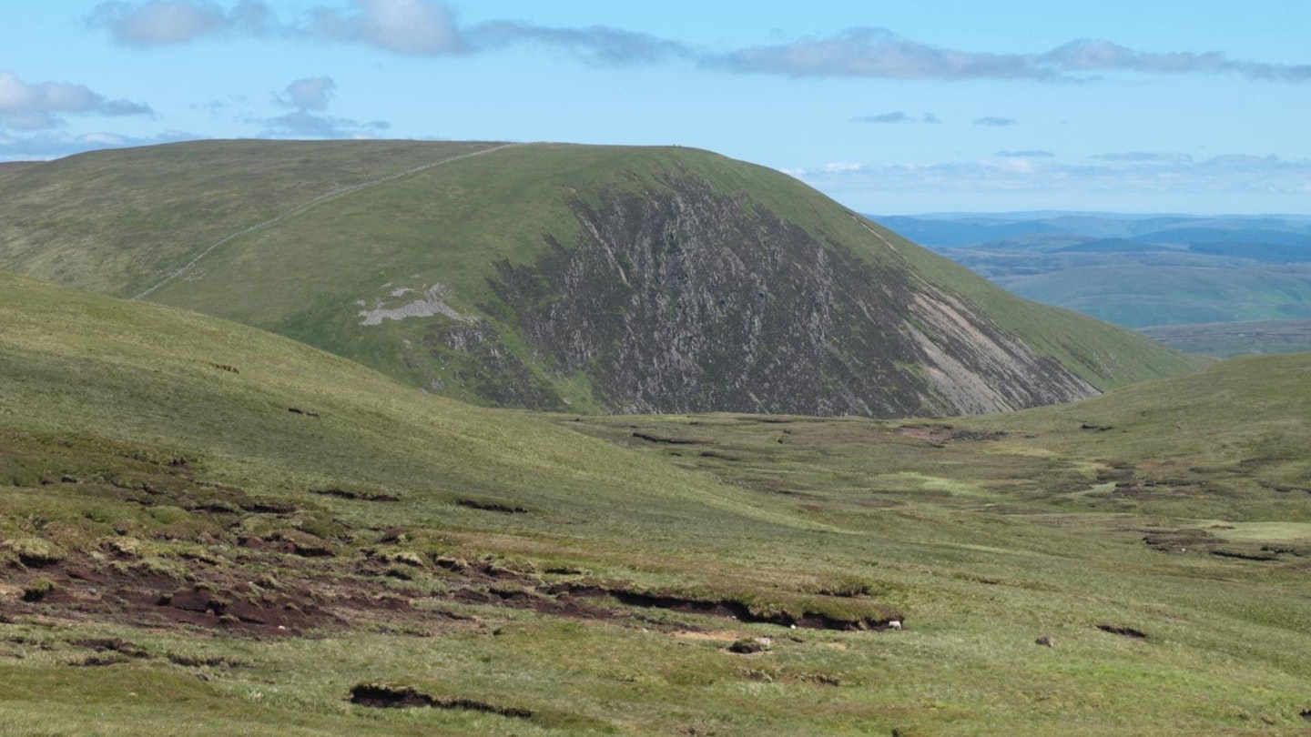
Cross the stile and turn right, following a fence and old wall south-south-west over Donald’s Cleuch Head and then up to Firthhope Rig. The views to the east and south have opened out now, taking in The Cheviot and the North Pennines in the distance. On reaching a meeting of fences on Firthhope Rig, turn left, following a fence east-south-east. It drops into a dip and then climbs towards White Coomb. Saddle Yoke and the hills surrounding Blackhope Burn – some of the most rugged ground in this part of the Southern Uplands – is to the south-west. Where the fence bends right, cross the tumbledown wall and follow a faint trail south-south-east to White Coomb’s cairn. Again, distant views dominate, with the Solway Firth and the Lake District fells now visible to the south.
-
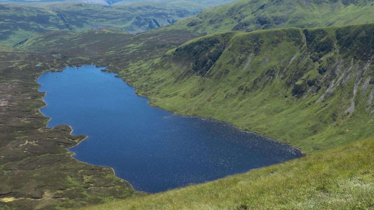
From White Coomb, retrace your steps to Firthybrig Head (waypoint 4). Ignoring the stile crossed earlier, turn right, following the fence and tumbledown wall east-north-east. As you descend, you get your first glimpse of Loch Skeen down to the right. Cross the boggy saddle of Talla Nick and then climb the far side. A meeting of fences is reached on Loch Craig. Before crossing the stile beside the locked gate here, head south to the prominent cairn and then continue downhill for a few more strides for a superb view of Loch Skeen directly below.
-
Return to cross the stile and then walk north beside the fence on your right, over the top of Lochcraig Head. Just beyond the cairns, bear left at a faint fork (north-north-west), soon enjoying views of Talla Reservoir down to the left. This trail cuts across to a fence heading north-west. Follow this into a slight dip before climbing Nickies Knowe.
-
Cross the stile on the summit and walk downhill, now with the fence on your left. The path comes away from the fence at times but doesn’t lose sight of it until you draw level with a gate in it – almost 1km beyond Nickies Knowe’s summit. Now bear right (north-west).
-
At the bottom of the ridge, go through a gate on boggy ground and swing slightly right. A faint path heads north-north-west, later swinging northnorth- east to cross a bridge and reach a gate just above a sheepfold. Once through the gate, turn left along the road. It’s now about 1.2km back to the parking area. The Megget Stone, thought to be an old boundary stone, is passed along the way – beside a cattle grid at the brow of the hill.
What walking gear do I need for this route?
Here's a selection of the best walking gear selected by LFTO's testing team: Walking boots | Hiking daypack | Waterproof jacket | Walking trousers | Walking poles | Walking mid-layers | Base layers
Where can I eat and drink?
There is a good choice of restaurants, cafes, pubs and takeaways in Moffat, 24km south of Tweedsmuir on the A701.
Where's the best place to stay?
Moffat also has hotels, B&Bs, campsites and a hostel (moffathostel.com) with small dorms and private rooms.
About the author
Vivienne Crow is an award-winning outdoor writer and photographer with an all-consuming love of walking and the natural world. Vivienne specialises in all things to do with the Lake District and Cumbria, her adopted home county, but travels far and wide in her camper van, writing about walks, destinations, natural history and human heritage throughout the British Isles – often with her terrier Jess in tow.
This route originally appeared in the November 2024 issue of Trail magazine. CLICK HERE to become a Trail magazine subscriber and get 50% off a whole year of digital OS Maps