
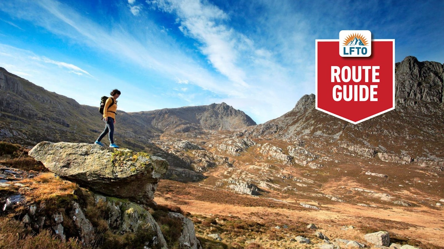
Classic Eryri (Snowdonia) landscapes underfoot and for the eye; with rugged ground and dramatic views of familiar summits including Cwm Tryfan. If you fancy a change of scene and character, consider this outing from the village of Capel Curig (meaning ‘Curig’s Chapel’).
Usually quiet, with a remote feeling that belies quite how accessible this high ground can be, this parade along the eastern reach of the Glyderau mountain range is well worth any slight detours from old favourites.
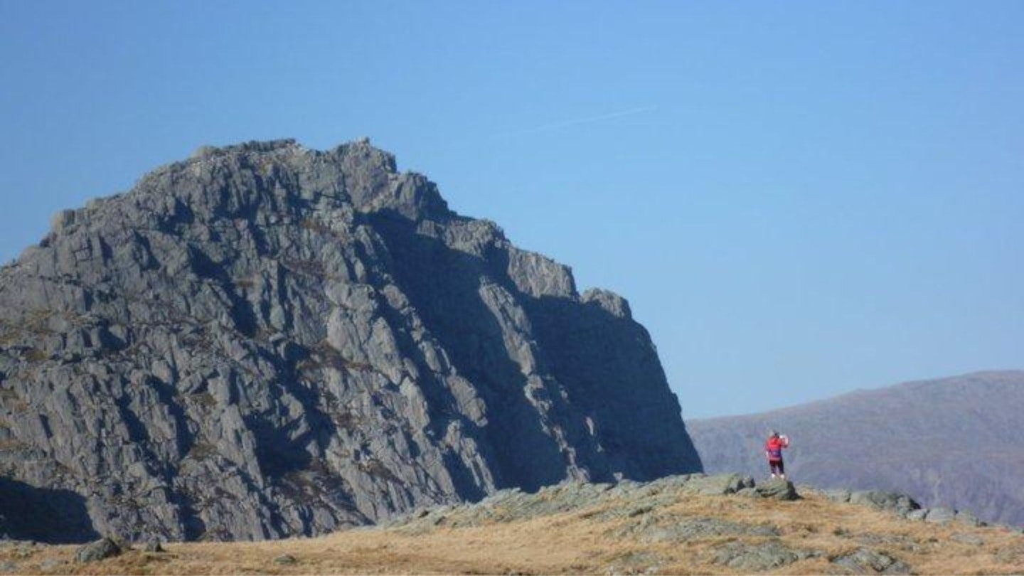
Expect varied terrain, sometimes wet underfoot, but if you catch a dry day with good visibility, you’ll be well rewarded with glorious views to some classic Eryri mountains, especially a close-up look upon Tryfan’s craggy east face, on descent from Y Foel Goch.
Capel Curig offers an excellent base from which to explore, where the rocky heights of the Glyderau come to rest with the meeting of the river Afon Llugwy and outflow of the Llynnau Mymbyr lakes. In very high rainfall, the low ground of Capel Curig can be flooded and autumn colours look resplendent in the pockets of native woodland in the valley. There is always something to discover every season and in every valley in Eryri. Plan, walk, look, then look again.
How hard is hiking Y Foel Goch and Cwm Tryfan?

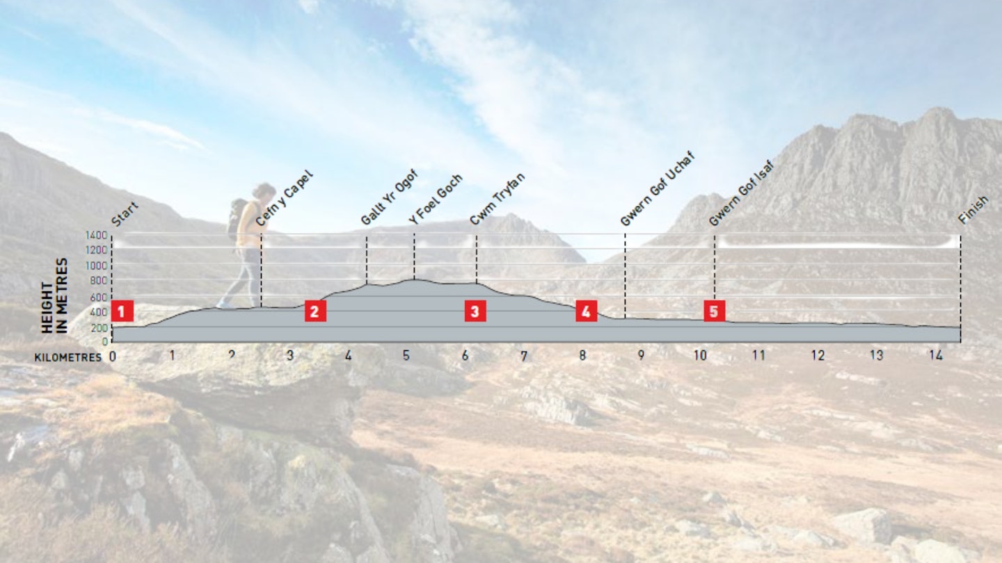
DIFFICULTY: Medium | DISTANCE: 14.5km | TIME: 5 hours | TOTAL ASCENT: 735m
FITNESS: Good level of hill fitness needed, including ability to tackle steeper slopes/rocky steps. Walk back to Capel Curig maintains distance, with less ascent/technical effort.
TERRAIN: Low-grade mountain paths (with boggy/muddy areas), grassy trods, and rocky ‘scree’ paths.
NAVIGATION: If low visibility at Y Foel Goch summit, expect vague, grassy terrain, before joining clearer path into Cwm Tryfan.
Where is the start of the walk?
Capel Curig. This is is served by Sherpa’r Wyddfa buses S1 and T10. Eryri National Park car park behind Joe Brown, Capel Curig (pay to use public toilets).
What's the best map for Y Foel Goch and Cwm Tryfan?
-
CLICK HERE to view and download our digital route guide in OS Maps
-
OS Explorer OL17 (1:25k)
-
OS Landranger 115 (1:50k)
-
Harveys British Mountain Map – Snowdonia North (1:40k)
Y Foel Goch and Cwm Tryfan | Step-by-step route guide

-
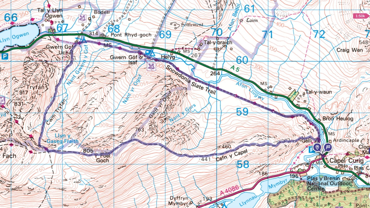
The route starts from the triangular road junction in Capel Curig (A4086/A5). Buses stop nearby, or you can park in the small car park behind Joe Brown’s outdoor shop. Follow the small lane, north-northwest, passing Joe Brown shop buildings and crossing the Afon Llugwy. The lane rises uphill towards a gate and continues towards a farm building on your left, passing through a second gate. You now have just over 3km of uphill effort, weaving through a mixture of rocky and broken ground and ferns, to reach more open, upland terrain. There’s no missing the latter, rising to your left from the farm, Gelli (Welsh for ‘copse or area of trees’). Strike out on to this open access land, and there is a modest path to follow, heading generally west, and the ground is steeper for the first kilometre. After the 400m contour, the slope angle starts to ease, with undulating walking along Cefn y Capel, crossing over a wall at the 440m contour. Continue generally west along rising ground and reach a second wall crossing at the 520m contour.
-
Cross the wall and a distinct change of slope angle kicks up ahead of you for 200m in height. Mostly grassy, with some broken ground. Keep to a boundary wall for 500m distance, before the path strikes west, gaining height through larger boulders and small crags dotting the hillside towards Y Foel Goch’s higher summit area. Approaching the 805m high summit, there are steeper slopes down to your right, but the summit ground is quite easy-going, albeit decorated with many rocky features standing out from the grass around. Still heading west, rise over this quiet summit, with its panoramic views. Then, descend west down grassy/rocky slopes, passing the waters of Llyn y Gaseg-fraith and after 1km reach the point where a path heads off north (to your right). There is a large bulge of rock on the northerly edge of the cwm here.
-
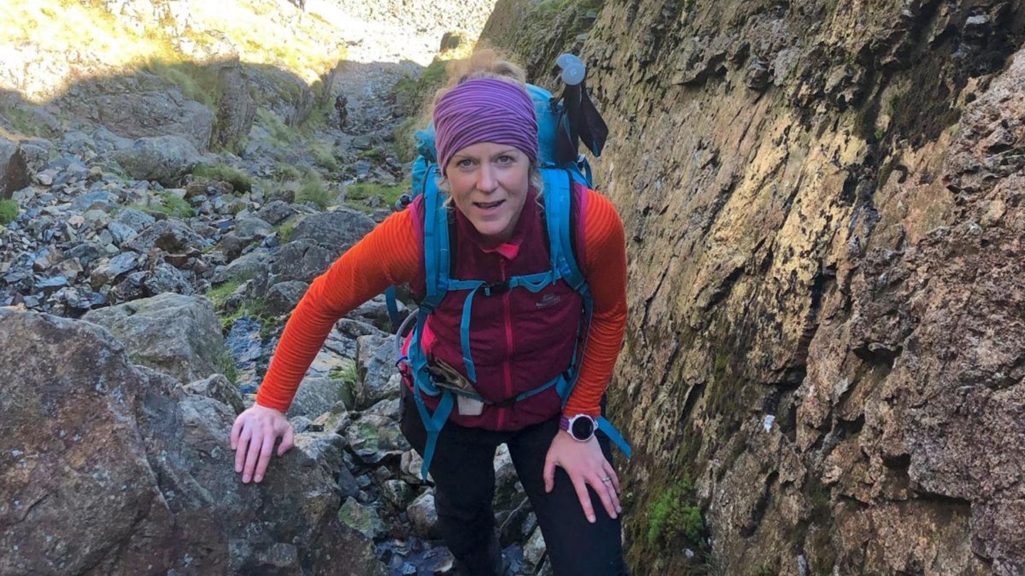
The top of the descent route may be tricky to spot initially, but it becomes much clearer as you work your way below the 'bulge’ of rock at the top of this slope. Follow a narrow path (heading north-west) down through larger boulders and rocky steps, dropping you into the head of Cwm Tryfan, with steeper slopes above, on your left. This stony path contours across the cwm, heading for a gap below Tryfan’s South Ridge (Bwlch Tryfan), but 250m after leaving the ridge above, you need to turn right, further downhill into Cwm Tryfan, using a rough path/scree sections. Below the 650m contour, the ground becomes less steep and you’re now following a fairly rough and ready path descending through the cwm, generally north-north-east. Tryfan’s steep east face is to your left, above. Continue on this path for just over 1.5km, and reach a stile over a wall.
-
The next 500m section of path follows a pitched rock section, descending more steeply (and sometimes slippery when wet) with the small crag of Tryfan Bach to your left. Emerge on to flatter terrain with the path leading you in the direction of Gwern Gof Uchaf farm/campsite, visible ahead. Join a significant public bridleway, as it runs east/west on your side (south) of the farm boundary wall. Head east and use a bridge to cross the river Nant Gwern y Gof. Now heading east-south-east, this public bridleway follows the base of the valley back to Capel Curig, gently undulating at times, but offering an easy-going return route – albeit sometimes muddy when wet.
-
The route passes through another farm/campsite, Gwern Gof Isaf, keeping to the marked Right of Way and passing through a number of boundary gates. Once through the farm, follow the public bridleway for another4km. Arrive back at the farm at Gelli, where your walk started, and descend back down the lane towards the Capel Curig road junction.
What walking gear do I need for this route?
Here's a selection of the best walking gear selected by LFTO's testing team: Walking boots | Hiking daypack | Waterproof jacket | Walking trousers | Walking poles | Walking mid-layers | Base layers
Where can I eat and drink?
Fresh coffee and baked goods at Ogwen Cottage café kiosk (takeaway) or head to refurbished Tyn y Coed Inn, Capel Curig, for pub atmosphere.
Where's the best place to stay?
Excellent valley camping at Gwern Gof Isaf, with great views of Tryfan. Top hostel accommodation at The Rocks Hostel in Capel Curig – near start point.
About the author
This route was written up by Kate Worthington. If you find a route by Kate in Trail magazine or on Live for the Outdoors, you can be sure it's a cracker. Kate lives and works in the mountains of north Wales, where she's a director of RAW Adventures, plus a qualified Mountain Leader, Winter Mountain Leader and Fell/Trail Leader in Running Fitness.
This route originally appeared in the November 2024 issue of Trail magazine. CLICK HERE to become a Trail magazine subscriber and get 50% off a whole year of digital OS Maps.